
Business Details
37 Years
experience
Your Trusted Land Surveyors in Sale, Cheshire
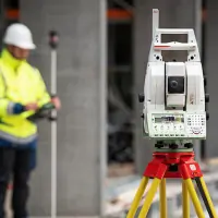
Established in 1989, CPLS Land Surveyors has built a reputation for delivering precise and reliable land and building surveying services across the UK. Our expertise spans topographical surveys, boundary delineation, digital terrain modelling, and measured building surveys, supported by state-of-the-art equipment including Leica TS 16 technology. Based in South Manchester but operating nationwide, we deploy specialist survey teams tailored to each project's requirements, ensuring compliance with quality and health and safety legislation.With decades of combined experience, our professionals prioritise accuracy in every survey, providing clients with detailed 2D/3D digital outputs and actionable insights. Our commitment to technological advancement and methodological rigour has made us a trusted partner for both public and private sector clients seeking dependable geospatial data.

Services
Topographical Surveys
Boundary Surveys
Measured Building Surveys
GPR Surveys
Digital Terrain Modelling
Deformation Surveys
Setting Out Services
Details
- Year established: 1989
Highlights and features
- We have over 35 years of experience in professional land surveying
- Our teams use state-of-the-art Leica TS 16 surveying equipment
- We operate nationwide with local expertise in Cheshire and Manchester
- We provide comprehensive digital terrain modelling and 3D outputs
- Our surveyors specialise in boundary resolution and measured building surveys
Services
Topographical Surveys
Using Leica TS 16 technology, we create detailed terrain models showing natural and man-made features. Our surveys include elevation data, boundary markers, and utility locations. Data is delivered in DWG/DXF formats for construction and planning purposes.
Boundary Surveys
We precisely determine legal property boundaries using digital measurements aligned with title deeds. Our reports resolve disputes and support land development projects with Ordnance Survey coordinate referencing.
Measured Building Surveys
Laser scanning captures building dimensions for floor plans, elevations, and cross-sections. We provide architectural details and structural data in digital formats for renovation or asset management.
GPR Surveys
Dual-frequency ground-penetrating radar locates underground utilities like gas, water, and cables. Results integrate with topographical maps to ensure safe excavation and construction planning.
Deformation Surveys
We track structural movements over time using precise levelling techniques. This service monitors building stability, bridge foundations, and infrastructure projects requiring movement analysis.
People
Cpls
Founder & Director
With over 35 years' experience in land surveying, Chris established the company in 1989. He oversees project quality assurance and technological development, ensuring adherence to industry standards.
Questions
What surveying services do you specialise in?
We specialise in topographical surveys, boundary surveys, measured building surveys, GPR utility detection, digital terrain modelling, and deformation monitoring using Leica equipment.
Do you operate outside Cheshire?
While based in South Manchester, we provide land surveying services nationwide across the UK for both public and private sector projects.
What technology do you use for surveys?
We use Leica TS 16 total stations, dual-frequency ground-penetrating radar, and laser scanners to ensure precise geospatial data collection.
How do you handle complex building surveys?
Our measured building surveys employ reflectorless total stations and laser scanners to create detailed floor plans, elevations, and cross-sections in 2D/3D formats.
Can you assist with planning applications?
Yes, we provide street scene elevations and digital terrain models that meet planning authority requirements for development applications.
How do I request a survey quote?
Contact us via phone or email to discuss your project requirements and receive a tailored quote for our surveying services.