Business Details
Hire Certified Drone Pilots Nationwide
Skykam Drone Inspections is a UK-based platform connecting clients needing drone services with CAA-certified, vetted drone pilots. Our streamlined process enables clients to submit project details once and receive multiple competitive quotes from professional operators. With a focus on quality and reliability, we ensure all pilots are fully licensed, insured, and equipped with cutting-edge technology. Our network spans the entire UK, from major cities to remote locations, providing coverage for diverse projects including real estate photography, industrial inspections, and topographical surveys. Founded by experienced GVC-licensed pilot Peter Leslie, we maintain rigorous standards by manually verifying and rejecting 73% of pilot applications. Our platform delivers actionable data rather than hobbyist imagery, ensuring survey accuracy, compliance evidence, and decision-ready visuals. We hold active CAA Operational Authorisation and maintain detailed safety cases, maintenance logs, and mission documentation for every sortie. Backed by nearly a decade of commercial flying experience across construction, infrastructure, and media sectors, we provide clients with trusted advisors for compliant aerial data capture. As members of ARPAS-UK and Dundee & Angus Chamber of Commerce, we actively contribute to shaping industry standards and supporting local businesses.
Services
Drone Photography
Roof Inspection
LiDAR Mapping
Thermal Imaging
Gas Detection
Solar Survey
Topographical Survey
Crop Spraying
Wedding Videography
Bathymetric Survey
Served areas
- Edinburgh
Highlights and features
- Drone Services
Associations and certifications
- CAA
What people say
Fantastic company
Absolute pleasure working
5-star service
Excellent results
Highly recommended
Services
Drone Roof Inspection
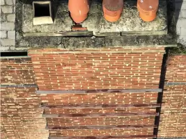
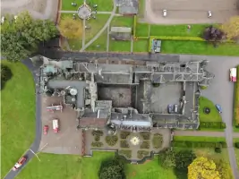
Our drone roof inspections provide safe, detailed assessments without ladders or scaffolding. Using high-resolution cameras and thermal imaging, we identify damage, heat loss, and electrical faults. Clients receive comprehensive reports with photographic evidence and insurance documentation.
Drone LiDAR Mapping
We create precise 3D terrain models using LiDAR technology for construction and infrastructure projects. Our mapping services deliver survey-grade accuracy with digital elevation models and point cloud data for engineering applications.
Drone Thermal Imaging
Thermal imaging services identify heat loss and electrical faults using FLIR camera systems. We provide energy audits for buildings and industrial facilities, detecting anomalies invisible to standard cameras.
Drone Gas Detection
Our optical gas imaging detects methane and hydrocarbon leaks in industrial environments. Using specialist OGI cameras, we perform pipeline integrity checks and safety assessments for energy sector clients.
Drone Solar Survey
Solar panel inspections identify hot spots and efficiency issues using thermal imaging. We provide detailed reports on photovoltaic system performance and maintenance requirements for renewable energy installations.
People
Peter Leslie
Director
GVC-licensed drone pilot with nearly a decade of commercial flying experience. Holds CAA Operational Authorisation and A2 Certificate of Competency. Former PfCO holder and founder of Skykam Drone Inspections's selective pilot network.
James Leslie
Operations
Manages day-to-day operations and client coordination. Oversees pilot vetting process and ensures compliance with CAA regulations across all drone operations.
Questions
How quickly will I receive quotes after submitting a project?
Clients typically receive their first quote within 1 hour, with most projects attracting 3-5 competitive bids within 24 hours.
Are all drone pilots properly certified?
Every pilot holds CAA GVC certification with full insurance coverage. We manually verify 100% of pilot credentials before platform access.
What areas do you cover across the UK?
Our network operates nationwide, from London to the Scottish Highlands, including all major cities and remote locations.
How do you ensure project compliance?
We document risk assessments, maintain pilot certifications, and provide audit trails for every project through our delivery hub.
What happens if I need project modifications?
Our concierge service helps adjust project details at any stage, coordinating changes with selected pilots and updating documentation accordingly.
Can I see pilot ratings and reviews?
Yes, all pilots display verified ratings and client feedback to help you make informed selection decisions.
Reviews (4)
Orla Barr
Nov 22, 2021
Report
We were very impressed with how professional Skykam was in the drone service they provided. The aerial pictures and videos you captured gave us a fantastic new perspective of our location that we will be able to use in our marketing campaigns.
Lee Retallic (www.leeshovervision.com)
Nov 18, 2021
Report
James at Skykam is very responsive and professional. He helped me out with some drone surveys at the last minute meeting the deadline for the surveyor and collecting all relevant data on time.
Alice Christison
Nov 18, 2021
Report
I contacted James about using a drone for a roof inspection for a potential customer. James has been very responsive to my questions and was able to help me quickly understand the process of how the drone would be used, etc. The drone was perfect for the job. James took some amazing aerial photos and videos of the roof. I will use your services again, and recommend your company to others. Thank's for the help James.
David Macdonald
Nov 02, 2021
Report
We used Skykam recently and have been absolutely delighted with the service and finished job.
James went above and beyond to ensure our vision was met and I can only thank him for this. The cost was as quoted for with no hidden extras and came in on time. We would 100% recommend Skykam and will be using again in the future.
James went above and beyond to ensure our vision was met and I can only thank him for this. The cost was as quoted for with no hidden extras and came in on time. We would 100% recommend Skykam and will be using again in the future.