Business Details
Expert Environmental Services in Keyworth
As the national geological survey of the UK, we are a world-leading independent research organisation dedicated to providing objective, expert geoscientific data and knowledge. Our work spans environmental monitoring, geological research, and hazard resilience, supporting sustainable development and informed decision-making. With over 180 years of operational history, we combine extensive experience with cutting-edge technology to address global challenges such as climate change, decarbonisation, and natural disaster preparedness. Our multidisciplinary team of geoscientists delivers authoritative insights through advanced data infrastructure, including the National Geoscience Data Centre and National Geological Repository. We collaborate with governments, academia, and industry partners worldwide to enhance understanding of Earth systems and promote responsible resource management.Our commitment to impartiality ensures all findings are evidence-based and accessible, fostering trust in our scientific leadership. Through initiatives like OpenGeoscience, we provide free public access to extensive datasets, maps, and educational resources. Our ISO-certified quality management systems guarantee rigorous standards in all research outputs. By integrating field observations, laboratory analysis, and digital modelling, we develop practical solutions for energy transition, water security, and urban resilience. Our strategic priorities align with UN Sustainable Development Goals and UK net-zero targets, positioning us at the forefront of geoscientific innovation for societal benefit.
Services
Geological mapping
Hazard monitoring
Data licensing
Environmental research
Digital geoscience
Resource assessment
Marine geology
Urban resilience
Climate studies
Educational resources
Highlights and features
- We have over 180 years of continuous geological research experience
- Our data infrastructure supports global geoscience innovation
- We deliver actionable insights for climate resilience and decarbonisation
- Our ISO-certified quality management systems ensure rigorous standards
- We maintain the UK's national geological data collections
Associations and certifications
- ISO 9001
- ISO 14001
- ISO 27001
Services
Geological mapping
We create detailed geological maps using advanced surveying techniques and satellite data. Our maps help urban planners, engineers, and environmental scientists understand subsurface conditions. This service supports infrastructure development and natural hazard mitigation across the UK and internationally.
Hazard monitoring
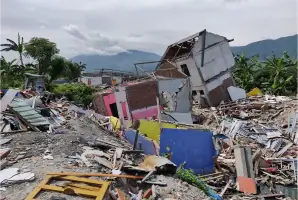
Our real-time monitoring systems track seismic activity, landslides, and volcanic processes. We provide early warning systems and risk assessments for governments and emergency services. This work enhances community resilience to natural disasters through scientific data analysis.
Data licensing
We offer licensed access to over 400 geoscientific datasets. Our digital archives include borehole records, rock samples, and environmental monitoring data. This service supports academic research, commercial projects, and policy development with authoritative geological information.
Environmental research
Our scientists conduct cutting-edge research on climate change, groundwater systems, and resource sustainability. We investigate Earth processes to inform environmental policies and industrial practices. This work combines field observations with laboratory analysis and computational modelling.
Digital geoscience
We develop innovative digital tools including interactive map viewers and 3D geological models. Our OpenGeoscience platform provides free access to maps, photos, and datasets. This service promotes data transparency and supports geospatial analysis for diverse applications.
Questions
What geoscientific services do you offer?
We provide geological mapping, hazard monitoring, environmental research, data licensing, and digital geoscience tools to support sustainable development and risk management.
How can I access your geological data?
Our OpenGeoscience platform offers free access to maps, datasets, and publications. Commercial users can obtain licensed access to specialist data collections.
Do you conduct international research?
Yes, we collaborate globally on projects addressing climate resilience, resource management, and hazard mitigation through institutional partnerships.
How do you support environmental policy?
We provide independent scientific advice to UK and international governments on climate change, decarbonisation, and sustainable resource use.
What educational resources are available?
We offer free teaching materials, interactive map viewers, and loanable geological kits for schools and public education programmes.
How do you monitor natural hazards?
We operate real-time monitoring networks for earthquakes, landslides, and volcanic activity, providing data for early warning systems and risk assessments.